

Storm Doris to smash Britain with snow and 80mph raging winds as Met Office warns people ‘be prepared’
Widespread disruption could hit the travel network and there are fears "flying debris" may cause various accidents

STORM Doris is braced to smash into Britain with ferocious 80mph raging winds and snow, the Met Office has warned.
Wintry showers with powerful gusts could hit the UK this week, leading the national forecaster to warn people: "Be prepared."


The long-awaited Storm Doris was expecte
There were concerns Doris would hit earlier this month but the weather never reached the threshold needed to be classified as a storm by the Met Office.
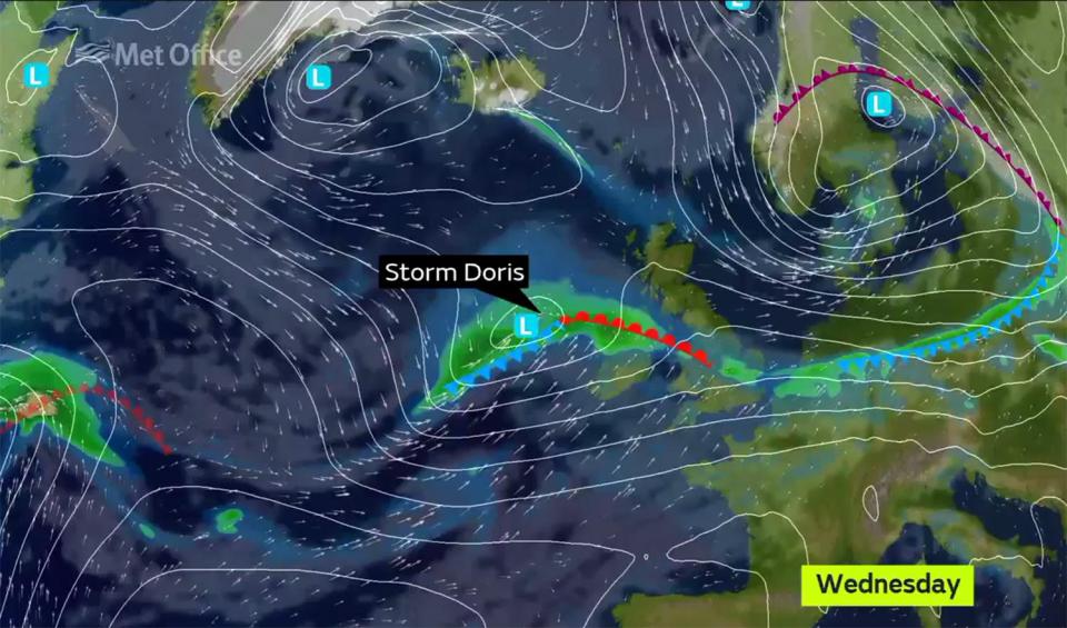
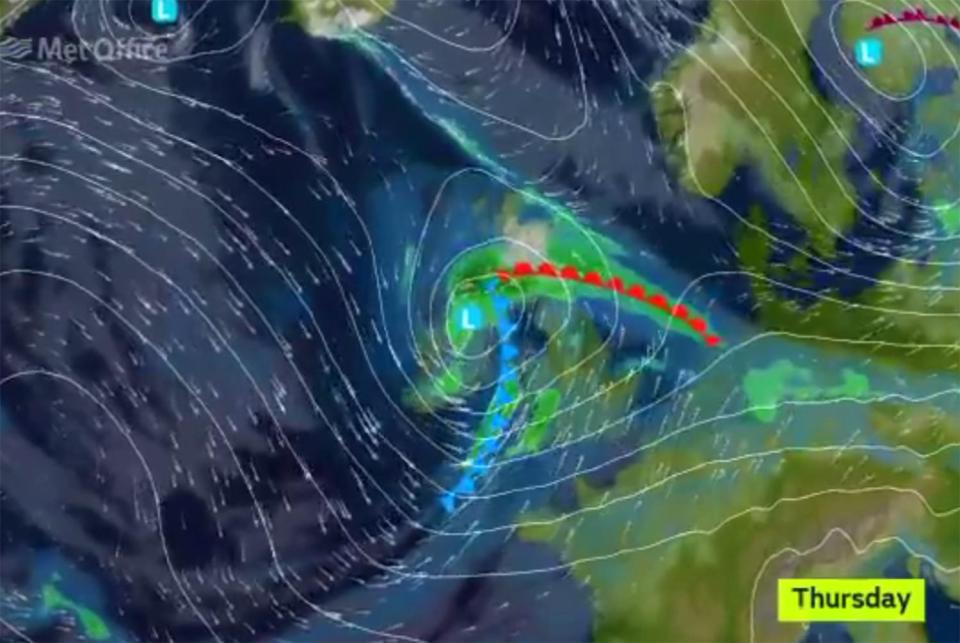
Forecasters re-evaluated this position earlier today and announced Storm Doris had formed and was heading for the UK on Thursday, bringing with it snow, rain and 80mph winds.
This time last year, the UK had already been hit by nine named storms but Doris is just the fourth - following Angus, Barbara and Conor.
The Met Office only names storms when forecasters believe them to have the potential cause amber 'be prepared' or red 'take action' warnings and do this in order to make people more aware of sever weather.
The stormy conditions follow a warm air blast from tropical America which pushed thermometers into double figures.
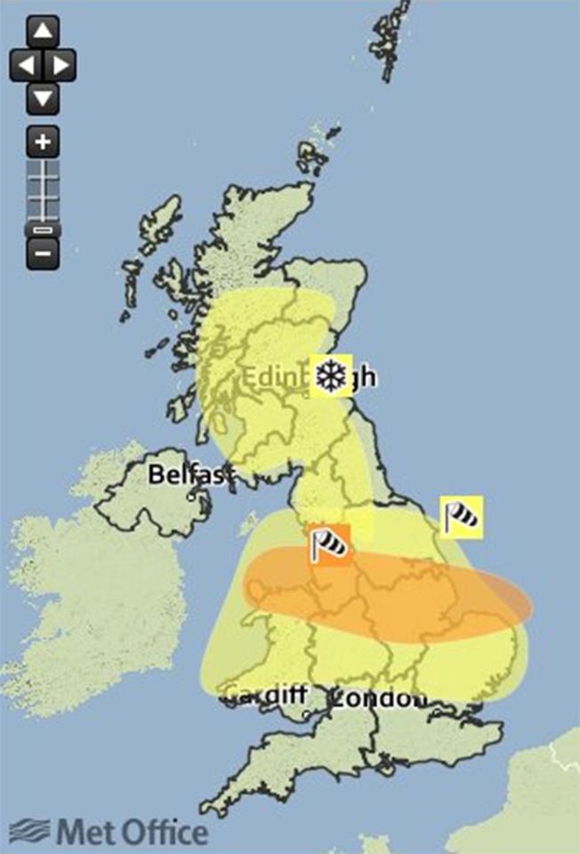
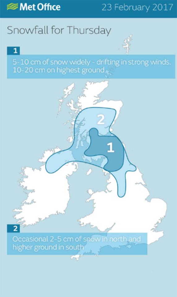
Now the Met Office has issued for snow and wind from the early hours of Thursday morning.
The warnings state: "Snow is expected over high ground of northern England and Scotland on Thursday and may fall to low levels for a time in Scotland.
"In addition, strong winds are expected to develop with gusts of 50 to 60 mph. This will result in drifting of the snow and blizzard conditions over high ground. Associated heavy rain at lower levels will be an additional hazard.
"The combination of snow, strong winds and heavy rain is likely to lead to disruption to transport networks and perhaps power supplies."
RELATED STORIES


The Met Office said that stronger winds may develop across parts of "northern England, northern Wales and the north Midlands".
They added: "Some very strong winds are expected throughout Thursday in association with storm 'Doris', with a short period where gusts of 70 to 80 mph are possible.
"Whilst the strongest winds look to be only short-lived, damage to structures, interruptions to power supplies and widespread disruption to travel networks are likely, with a danger of injury from flying debris."
The warnings mark a dramatic change from the weekend when the mercury rose to 15C (59F), around 10C higher than average for mid-February.
Thermometers hit 18.3C (65F) in the south yesterday while the north enjoyed highs of 15C plus making it the warmest day of winter.
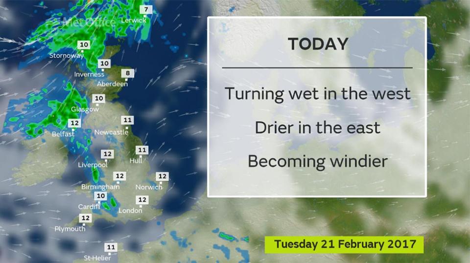
The Met Office said wind and rain will set in tonight before a more powerful storm system hits on Thursday.
Spokeswoman Nicola Maxey said: “Although Tuesday will be mild it will not be as warm as Monday although temperatures will still be above average.
“Rain will start to move in later in the day and some of this could be heavy, it will also be quite gusty as winds pick up overnight into Wednesday.
“Gales could bring gusts speeds of 60knots [69mph] into Thursday and as it turns colder there is a risk of snow which could be heavy over 400 metres
“Although a name has not been issued for Thursday’s system there is the potential for this to happen, the next storm name would be Doris.”
The turbulent weather is being blamed on a powerful jet stream stretching over the Atlantic dragging storms into the UK.


WeatherOnline forecaster Garry Nicholson said: “A changeable weather pattern will dominate during the week ahead as several frontal systems move in from the Atlantic.
“Rain will be frequent, and there will be gales at times.
“Temperatures will drop compared to the very mild values seen earlier this week, and there may be snow on northern hills.
James Madden, forecaster for Exacta Weather, claimed there is the risk of more widespread snow into next month.
He said: “It is likely that there will be some rather chilly evenings under clearer skies this week with some dense pockets of fog developing in places.
“This will pave the way for a colder weather pattern, we could see further snow during the final third of the month and into the start of the meteorological spring.”
Temperatures will remain above average today hitting 13C (55.4F) in the south and between 6C (42.8F) to 8C (46.4F) in the north.
By the end of the week London and the south can expect highs of 11C (51.8F) or 12C (53.6F) while elsewhere will struggle to get much above 5C (41F).
At the beginning of February, the UK suffered half a month’s rainfall in one day and faced 70mph winds.
We pay for your stories! Do you have a story for The Sun Online news team? Email us at [email protected] or call 0207 782 4368