WINTER IS HERE
Arctic air to hit this weekend bringing -7C chill, up to 12INS of snow & travel chaos for millions heading back to work
Watch the full forecast in the video player

BRITS are are bracing for -7C arctic temperatures and up to 12 inches of snow this weekend with travel chaos on the cards for millions.
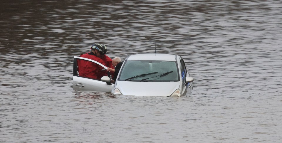
An ice warning is in force for much of the UK today as temperatures dropped after a major incident was declared due to flooding which left towns across the nation underwater.


Now millions of Brits heading back to work and school on Monday could face some difficult travel conditions.
The Met Office said in their latest forecast that "cold arctic air" will sweep across the country on Saturday.
And Sunday brings the risk of "heavy snow and freezing rain" as wintry weather truly begins to take hold.
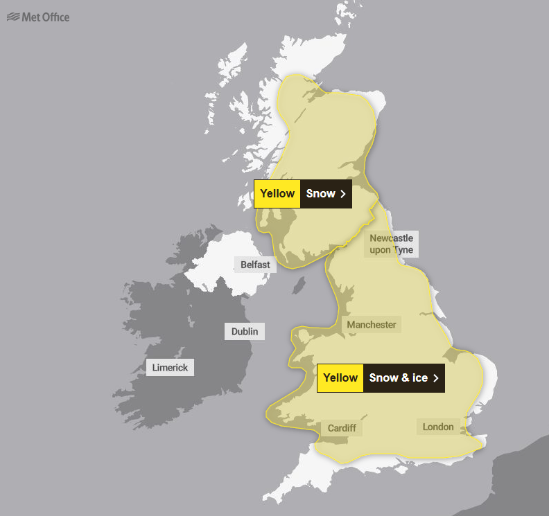
A yellow Met Office warning has been issued across Scotland, northwest England and Northern Ireland until 10am on Friday.
A snow and ice warning is also in place covering northern Scotland as rain turning to snow is likely to lead to some travel disruption and difficult driving conditions.
While an amber cold weather health alert has been issued for the whole of England until January 8.
For those who intend to travel despite the current wintry weather both the Met Office and National Rail issued alerts to remind Britons to plan ahead if on the move on Thursday.
Difficult driving conditions should be expected particularly within areas under a yellow weather warning.
Allowing extra time is also advised with delays, diversions or hampered conditions likely for road users.
For those using public transport, passengers are advised to check any timetables and services before setting out in case of delays or cancellations due to inclement weather.
The poor weather will impact trains running across Great Britain with Northern services, TransPennine Express services, Transport for Wales services and ScotRail services all impacted.
Two new flood alerts were issued just prior to 6am on Thursday with river levels peaking for both the Lower River Wharfe system in Yorkshire and Lower River Ure waterway in North Yorkshire.
The water levels mean both the Wharfe and Ure river systems and surrounding tributaries are at risk of flooding.
Areas most at risk within the Lower River Ure system include low-lying land including agricultural land and local roads in the areas around Masham, Boroughbridge, Aldborough and Bishop Monkton.
For Lower River Wharfe, areas at risk of flooding span from Otley to upstream of Ulleskelf including Tadcaster.
No further significant rainfall is expected for Thursday in the area with water levels expected to begin falling in the coming hours.


Britons in the area are advised to avoid using low-lying footpaths or any bridges near local watercourses and to not attempt to walk, drive or cycle through flood waters.
It comes after a major incident was declared in Greater Manchester on Wednesday after flooding forced homes to be evacuated and closed train lines and roads following heavy rain.
Mountain rescue teams were deployed to help Greater Manchester Fire and Rescue Service deal with damaged properties and stranded vehicles.
The police force said that the affected areas still under monitoring were Didsbury, Stockport, Trafford and Wigan.
Around 450 people were evacuated on Wednesday evening from a Didsbury hotel while 400 homes were at a lower risk with no widespread evacuation needed.
Residents were also evacuated from a block of flats in Meadow Mill, Stockport.
The North West and Wales saw heavy rain on Wednesday with Marsden seeing 101.2mm of rainfall - more than West Yorkshire's January monthly average of 85.1mm.
Capel Curig in Wales measured 101.2mm which is less than a third of the monthly average of 327mm.
A number of train routes were disrupted or blocked by flooding on Wednesday, mainly in the North West of England, with some Northern services, TransPennine Express services, Transport for Wales services and South Western Railway services affected.
National Highways said a section of the A628 Woodhead Pass between Woolley Bridge and Flouch was closed due to flooding as was the westbound M56 between Junction 6 for Manchester Airport and Junction 8 for Bowdon.
In Bristol the Severe Weather Emergency Protocol has been activated by Bristol City Council and homeless charity St Mungo's which will run until January 8.
Today:
It will be a cold but mostly sunny day across the UK. Wintry showers for coasts exposed to the northerly breeze and North Sea.
Remaining blustery in the north and east with lighter winds elsewhere.
Tonight:
A cold and frosty night will then follow for all with icy stretches possible.
Wintry showers will persist in the north and patchy freezing fog is possible in the west.
Friday:
Cold again with plenty of winter sunshine on offer, especially in the south and east.
Wintry showers affecting northern and western coasts, winds staying generally light.
Outlook for Saturday to Monday:
Possibly disruptive rain and snow arriving in the south on Saturday, moving north into central areas on Sunday where it will turn milder.
Colder, drier with wintry showers on Monday.
Temperatures were forecast to drop on Wednesday evening and reached -7°C or minus -8°C in Scotland overnight.
The maximum temperatures on Thursday are expected to be low- to mid-single figures.
Marco Petagna, senior Met Office meteorologist, said: "Most roads will be treated, there's a chance on untreated roads that ice will still be an issue.
"On Friday I think we will see further snow and ice warnings issued."
And a three-day yellow warning for snow has been issued for almost all of the UK this weekend as the Met Office warned that rural communities could become cut off.
Schools could potentially be closed and there is a chance of power cuts and road closures as well as delays and cancellations to flights and trains.
A yellow warning is in place from noon on Saturday until midday on Monday and covers the majority of the country.
About 5cm of snow is expected widely across the Midlands, Wales and northern England with as much as 20-30cm over high ground in Wales and/or the Pennines.
Thursday will otherwise be fine and dry for most although the temperature will feel much colder than the true mercury figure.
The chill will continue into Friday.
With the end of the week comes the threat of overnight ice extending south as far as the South West of England.
Met Office meteorologist Tom Morgan said: "At the moment we've issued a very large snow warning for Saturday until Monday but it doesn't mean that everywhere within that warning could see snow, it's just a heads-up there could be some impacts."