
BRRR-ITAIN
UK weather: Met Office map shows cold Arctic air creeping across Britain in hours as temperatures drop steeply from 19C
Scroll down see the full forecast for this week as temperatures plummet

COLD Arctic air is set to creep across Britain in just hours pushing temperatures steeply down from the toasty 19C seen at the weekend.
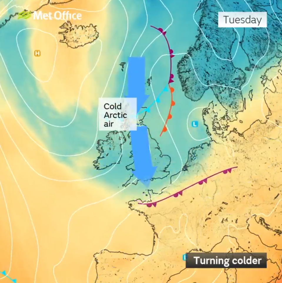
The Met Office has released a map showing how the colder conditions will sweep across the country from the north beginning on Monday evening.


Temperatures reached a high of 19.7C on Sunday in Crosby, Merseyside, but colder conditions are set to take hold this week.
Met Office Meteorologist Alex Burkill said: "It is going to turn quite a bit chillier for all of us.
"There's going to be a northerly wind pushing its way down.
"There's some markedly colder air that's going to push its way southwards as we go through today [Monday] into tomorrow and so temperatures are really going to drop."
By Tuesday morning, temperatures as low as 1C are expected in parts of southern Scotland, Northern Ireland, and northern England.
Alex said: "A touch of frost [is] quite likely.
"Even perhaps some icy patches to watch out for.
"But where it's cloudier it's going to be that little bit milder."
He warned that showers and potentially sleet and snow could be seen in the Highlands of Scotland as we head into Monday evening.
The map reveals how northern areas will be hit by the Arctic air first throughout Monday, while southern parts of the UK will feel the chillier conditions by Tuesday.
North-eastern regions are also expected to see some showers heading into the early hours of Tuesday.
On Tuesday morning, the forecaster said much of southern England would be cloudy while parts of Northern Ireland and the north of England are expected to have clearer skies.
Throughout Tuesday, however, Alex said the UK will be "largely dry", although there could be some scattered showers in parts of Scotland.
By the afternoon, temperatures are expected to reach a high of 10C in southern areas, with areas in the midlands likely to be a few degrees cooler.
This comes after Brits enjoyed summer-worthy sunshine over the end of last week and the weekend.
On Thursday, the highest temperature of the year so far was recorded in Santon Downham, Suffolk - with a tropical 19C.
Met Office spokesman Oli Claydon described the conditions as “very pleasant”.

This Evening and Tonight:
Cloudy in the south with outbreaks of patchy rain clearing southwards.
Clear spells and showers elsewhere, these turning wintry over hills in the north.
A patchy frost developing in central and northern areas with brisk northeasterly winds.
Tuesday:
Early cloud and rain clears the south.
Sunny spells and showers follow, turning wintry over the hills in Scotland and northern England.
Feeling colder than of late.
Outlook for Wednesday to Friday:
Rather cloudy, although brighter spells are likely at times.
Scattered showers continuing to spread across the country with sleet and snow over northern hills.
Cold with overnight frosts and ice.


